Showing 8 items matching world war ii aerial photographs
-
 B-24 Liberator Memorial Restoration Australia Inc
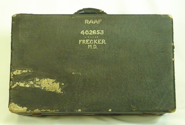
Suitcase from Mason Day Frecker, 1930s
... world war ii aerial photographs... include World War II medals awarded to the owner, photographs ...Suitcase issued to aircraft captains or crew by RAAF during World War II. The contents of M D Frecker's suitcase include World War II medals awarded to the owner, photographs, maps, pilots' handbooks, language dictionaries (Malay, Pidgin, Japanese), propaganda leaflets dropped by Japanese.Has historical and social significance, also research significance. Provenance known, owner piloted B-24 Liberator bombers and General Blamey's personal aircraft; item was donated by son. Great interpretive potential.Worn dark suitcase belonging to Mason Day Frekker, strong cardboard covered with 'leatherette', metal fasteners on front, with carry handle. Suitcase contains Flying Log Book RAAF, Wedding Photo, National Archives Record Search Mason Day Frecker, Distinguished Flying Medal Register WW2 x 3, Papers on Medals and Victorian Ground Crew Numbers, Files 1 - 2 - 3 - Photographs, Leaflets, Pilots' Notes, Maps - Germany (28 maps), Buttons and badges and other medals."RAAF/402653/Frecker/M.D." on top surface, "M.D.F." on front surface under handle.b24 liberator bomber, world war ii, raaf pilot, world war ii aerial photographs, a22.00 -
 The Beechworth Burke Museum
Photograph, 1944
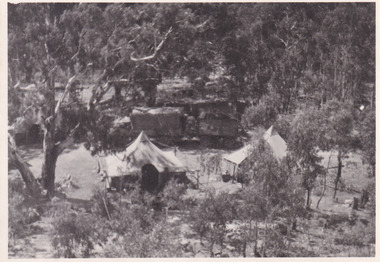
Taken in 1944, depicted is an aerial view of an Australian military camp set up at Mt. Stanley in Victoria. There are two large tents along with a vehicle and trailer surrounded by bushland. A secret experimental micro-wave radio station was established and tested at this site by the Army Signal Detachment Unit during World War II. It was part of an experimental Ultra High Frequency (UHF) link between Melbourne and Sydney. At the time, it was highly classified. It intended to enquire into the hitherto unexplored transmission of micro-waves; that is, a radio signal which could only be transmitted by line of sight, and thus required hill-top to hill-top location.The photograph is historically significant as it pertains to World War II; the largest global conflict in history. This significance is enhanced by Australia's prominent involvement in campaigns across the Pacific, particularly on land in New Guinea and across the Huon Peninsula. It was also the first time that the Australian mainland came under direct attack by the Axis, with Japanese forces targeting north-west Australia and Sydney Harbour. These battles became Australia's largest and most complex offensives during the war. The record is also historically significant as it relates to the Royal Australian Corps of Signals, or "RA Sigs". This significance is strengthened by Australia's unique distinction of having the first established signal unit under the British Empire. This unit provides electronic warfare. They enable commanders to implement highly dynamic battle control against opposing forces by using a number of methods including radio, fibre optic, micro-wave, information systems and satellite links. The record has strong research potential. This is due to the ongoing scholarly and public interest in war, military history, the ANZAC legend, and the continuing existence of the RA Sigs. The historic context of this record can provide insight into Australia's history, military, technological innovation and advancements, as well as national economic, defence and foreign policies after 1945.Black and white rectangular photograph printed on matte photographic paper.Reverse: BMM5095.11 / Our camp / From the top. / (?) (?) /military album, army album, australian royal corps of signals, army signal detachment unit, mt. stanley, victoria, beechworth, wwii, world war ii, melbourne, sydney -
 Federation University Historical Collection
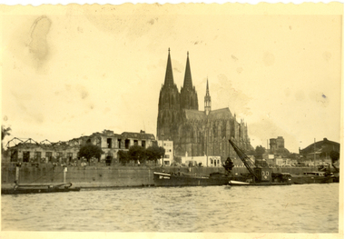
Photograph - black and white, Cologne Cathedral from the Rhine, c1950
Cologne Cathedral is a renowned monument of German Catholicism and Gothic architecture and is a World Heritage Site. It is Germany's most visited landmark, attracting an average of 20,000 people a day. (Wikipedia) Though not targeted itself, the cathedral was very near to the central railway station and suffered fourteen hits by aerial bombs during World War II. Badly damaged, it nevertheless remained standing in an otherwise completely flattened city. The twin spires were an easily recognizable navigational landmark for Allied aircraft bombing deeper into Germany, which may explain why the cathedral was spared. Repairs were completed in 1956. An emergency repair on the northwest tower's base carried out in 1944 using poor-quality brick taken from a nearby ruined building remained visible until 2005 as a reminder of the war, when it was decided to restore the section its original appearance. (Wikipedia) Black and white photograph showing a grand cathedral from a waterway. It is Cologne (Koln) Cathedral from the Rhine. To the left of the photo bombed buildings are evident. The photograph is believed to have been taken by Frank Wright.cologne cathedral, koln, germany, rhine, bombing, world war two, frank wright -
 Hume City Civic Collection
Photograph
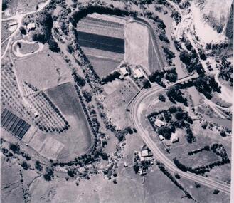
The aerial photograph shows the market garden situated on the river bend and flat of the Deep Creek at Bulla. In the 19th Century a hotel occupied the site. After World War II the property was owned by the Hughes family, who grew flowers. In 1971 Andrew Vlass purchased the property and it became a market garden until the Vlass family sold it in 1990.A black and white aerial photograph of the river bend and river flat of the Deep Creek at Bulla.scale - 170 feet = 1 inchdeep creek, market gardens, sunbury road, bulla, horticulture, hughes family, vlass, andrew, hotels, george evans collection -
 Port Melbourne Historical & Preservation Society
Photograph - Aerial view, Fishermans Bend, C D Pratt, 1945
Aerial photograph c1945 with the City of Melbourne in the foreground, showing Fishermen's Bend. Nissen huts are visible on the beach, as is one of the airfields. Fragment of photograph missing from bottom left hand corner and three significant tearsfishermans bend, war - world war ii, melbourne -
Port Melbourne Historical & Preservation Society
Photograph - Aerial view of Port Melbourne, 23 Dec 1945
One of three prints of aerial photographs of Port Melbourne 23.12.1945, showing different areas and to different scales: this one vertical, takes in Station and Town Piers, railyards, Missions to Seamen, Engine Works, temporary US wartime structures, edge of COR buildings, Swallow & Ariell, portion of Wiilliamstown Road. (Smaller copies located in A.06.04.B4)piers and wharves - station pier, piers and wharves - town pier, war - world war ii, built environment, transport - railways, missions to seamen, swallow & ariell ltd -
City of Kingston
Photograph - Colour, 6 March 1993
Edithvale is a suburb in the City of Kingston. It is located between Aspendale and Chelsea on the Port Phillip Bay and built within remnant areas of the Carrum Carrum swamp. The foreshore precinct comprises a wide sandy beach, with low sand dunes and numerous historic boat sheds. The suburb consists of older style dwellings and former holiday houses, combined with mid-century housing and newer homes. The large blocks are increasingly subdivided and the existing dwellings demolished to accommodate units and townhouses, thus changing the landscape of the area and reducing the tree canopy.The beachside suburb of Edithvale was previously part of the extensive Carrum Carrum Swamp. The area was once a source of fish and eels for the Mayone-Bulluk clan of the Bunurong people. Over time the area was drained and predominantly devoted to dairy farming and holiday houses. The farms were gradually sold and subdivided with a large number of homes built after World War II and in the 1960s. Edithvale is mainly residential with a shopping strip along Nepean Highway but little significant industry was ever established in the area apart from a plaster works and confectionary factory, both now closed.Laminated aerial colour photograph of Edithvale as viewed from Alexandra Avenue in the north to Ella Grove Chelsea/Edithvale in the south. regents Park Aspendale can be seen in the top left. The area is built-up with residential housing and facilities including Edithvale Primary School, numerous churches and the Edithvale Railway station. Large sections depict the remnant Carrum Carrum swamp. Edithvale Common and the former "Duck Inn" (Melbourne Water/Friends of Edithvale Seaford Wetlands) can be seen. Edithvale Recreational reserve, the valodrome and Edithvale Public Golf Course are prominent. The image shows vacant land in the area now known as Aspendale Gardens and the newer residential section of Chelsea Heights is not developed. A bike path has been established to cover the secondary drain. The Golf Links Court residential development located off Hughes Avenue is a large vacant block.Black type on white adhesive label: 6-3-93 Black type on white adhesive label: 25/9211, 6/3/93, 11.20 am Black type on white adhesive label: 9211 Yellow circular adhesive sticker Black pencil: 9211 6-3-93 arrow pointing Nedthvale, carrum carrum swamp, aspendale, chelsea -
City of Kingston
Photograph - Colour, Circa 1993
Edithvale is a suburb in the City of Kingston. It is located between Aspendale and Chelsea on the Port Phillip Bay and built within remnant areas of the Carrum Carrum swamp. The foreshore precinct comprises a wide sandy beach, with low sand dunes and numerous historic boat sheds. The suburb consists of older style dwellings and former holiday houses, combined with mid-century housing and newer homes. The large blocks are increasingly subdivided and the existing dwellings demolished to accommodate units and townhouses, thus changing the landscape of the area and reducing the tree canopy.The beachside suburb of Edithvale was previously part of the extensive Carrum Carrum Swamp. The area was once a source of fish and eels for the Mayone-Bulluk clan of the Bunurong people. Over time the area was drained and predominantly devoted to dairy farming and holiday houses. The farms were gradually sold and subdivided with a large number of homes built after World War II and in the 1960s. Edithvale is mainly residential with a shopping strip along Nepean Highway but little significant industry was ever established in the area apart from a plaster works and confectionary factory, both now closed.Aerial colour photograph of Edithvale as viewed from Alexandra Avenue in the north to Ella Grove Chelsea/Edithvale in the south. The area is built-up with residential housing and facilities including Edithvale Primary School, numerous churches and the Edithvale Railway station. Large sections depict the remnant Carrum Carrum swamp. Edithvale Common and the former "Duck Inn" (Melbourne Water/Friends of Edithvale Seaford Wetlands) can be seen. Edithvale Recreational reserve, the valodrome and Edithvale Public Golf Course are prominent. The image shows vacant land in the area now known as Aspendale Gardens and the newer residential section of Chelsea Heights is not developed. A bike path has been established to cover the secondary drain. The Golf Links Court residential development located off Hughes Avenue is a large vacant block.Yellow circular adhesive sticker on plastic Black ink (marker): * (asterisk) Black type on white adhesive sticker: P000108edithvale, aspendale, chelsea, carrum carrum swamp